

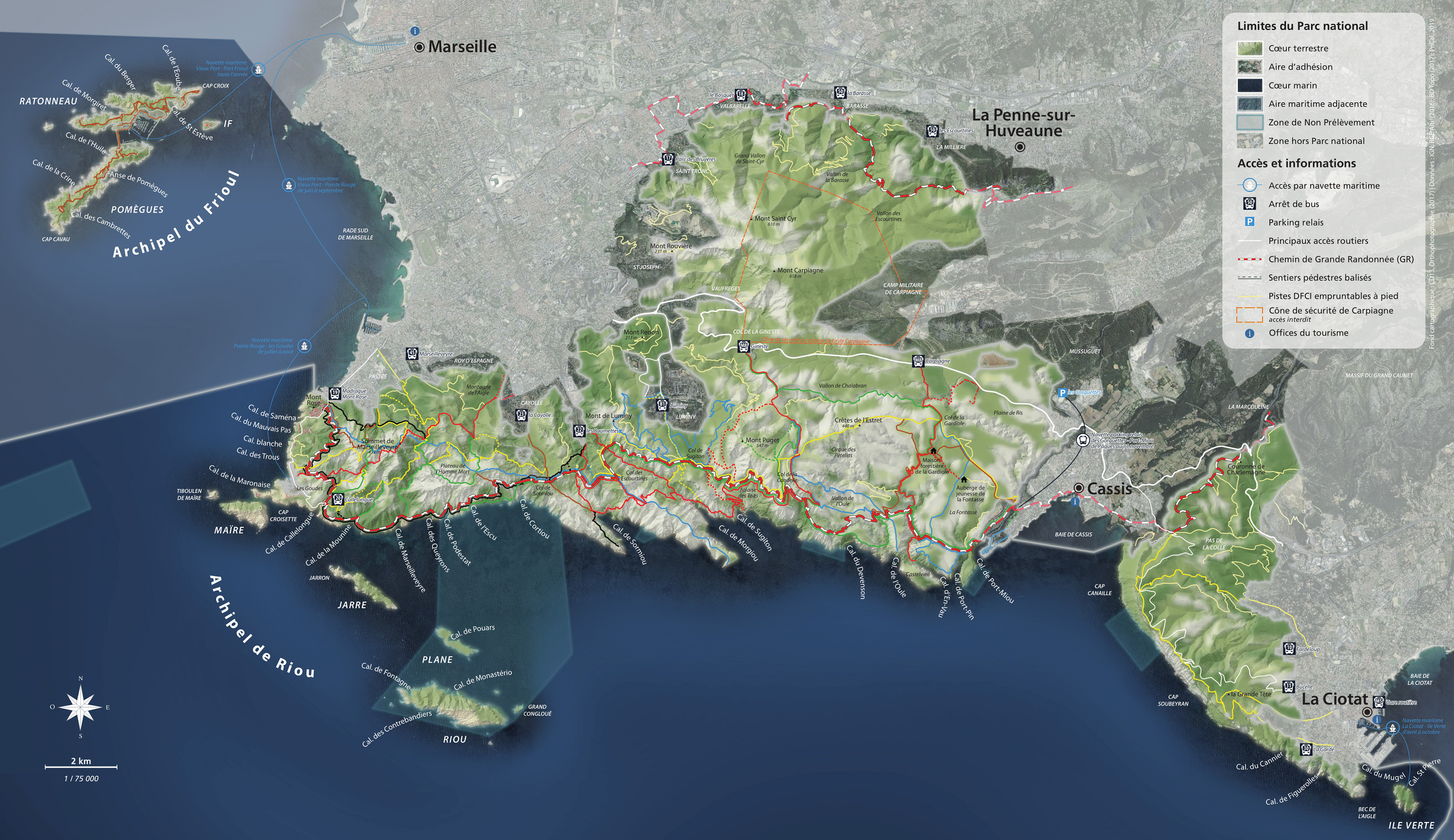
Getting to Marseile
By train: Marseille Saint-Charles SNCF railway station with Eurostar, Thalys, TGV Lyria, TGV high-speed railway and TER regional railway.
By coach: Marseille Saint-Charles coach station with Ouibus, Flixbus, Eurolines and Lignes Express Régionales Sud-Provence-Alpes-Côte d’Azur.
By car: motorways A7, A51, A55 and A50.
By plane: a direct shuttle provides daily transfers between the airport and Marseille Saint-Charles coach station.
By boat: the Marseille-Provence area has 24 marinas with temporary moorings and a range of services.
Getting to the Calanques
By bus: RTM buses provide services to Calanques National Park entrances. Public transport services also go to Cassis and La Ciotat from Marseille.
 Getting to Getting to |
 Bus no. Bus no. |
 plus walk for: plus walk for: |
|---|---|---|
| Mont Rose | 19 – direct Madrague de Montredon to terminus 583 in the evening |
approx. 5 minutes |
| to Goudes and Callelongue | as above, then 20 – direction Callelongue |
between a few seconds and a few minutes |
| to calanque de Marseilleveyre | as above, then 20 – direction Callelongue to terminus |
approx. 45 minutes |
| to Pastré and the top of Marseilleveyre | 45 – direction Marseilleveyre to terminus ou*r 19 - direction Madrague de Montredon, Montredon Pastré stop |
approx. 5 minutes to Pastré park and approx 1 hour to the top of Marseilleveyre |
| to Sormiou calanque | 23 – direction Beauvallon, La Cayolle stop or 22 – direction Les Baumettes to terminus |
approx. 45 minutes |
| to Morgiou calanque | 22 – direction Les Baumettes to terminus | approx. 1 hour |
| to Sugiton calanque | B1 – direction Campus de Luminy, Luminy – PN des Calanques stop 521 in the evening |
approx. 45 minutes |
| to Saint-Cyr range | 17 – direction Parc des Bruyères to terminus 18 – direction Le Bosquet to terminus 50 – direction Les Escourtines, La Barasse stop or to terminus |
under 1 hour to reach the valleys |
| to En-Vau lookout | M08 – direction Cassis, Carpiagne Gineste stop | approx. 2 hours |
By sea shuttle
- All year round, the Frioul-If express goes from the Vieux-Port to the Frioul archipelago.
- In summer, the RTM sea shuttle goes from the Vieux-Port and Pointe Rouge to Les Goudes port.
By bike
It is possible to cycle to all the entrances of the Calanques National Park. Some itineraries have bike paths, such as the whole trip from from Place Castellane to the Luminy campus (bike racks). Or hire a bike from the Marseille municipality self-service bike system to reach the southernmost point from docking stations in Pastré (docking stations no.8313 and 913).
By car
Driving to the Calanques is not recommended as parking is rare and unguarded. Take the usual precautions: lock your car, leave no valuable objects inside or visible.
Roads to Sormiou, Morgiou and Callelongue villages are closed to motorised vehicles as soon as the weather improves and throughout summer. La Gardiole track and track to Cap Croisette are now permanently closed.
Map of main entrances to the Calanques National Park
Click to zoom
 En lien
Things to see: the Calanques from Marseille
Calendar of road closures to Sormiou, Morgiou and Callelongue calanques
